There’s No Place Like Home


Vacationers dreaming of overseas travel are facing so many limitations that it seems the best place to visit is their own home town. OK maybe it is safe to visit any place in their state. Wait that might not be accurate either. Is it safe to visit Time Square in New York City?

Here is a list some of the State Department’s latest travel warnings and alerts.

Mexico Travel Warning:
We issue a Travel Warning when we want you to consider very carefully whether you should go to a country at all.

The U.S. Department of State warns U.S. citizens about the risk of traveling to certain parts of Mexico due to the activities of criminal organizations in those areas. U.S. citizens have been the victims of violent crimes, including homicide, kidnapping, carjacking, and robbery in various Mexican states. This Travel Warning replaces the Travel Warning for Mexico issued December 8, 2016.

Baja California (includes Tijuana, Rosarito, Ensenada, Tecate, and Mexicali): Exercise caution in the northern state of Baja California, particularly at night. Criminal activity and violence, including homicide, remain an issue throughout the state.

Baja California Sur (includes Los Cabos and La Paz): Criminal activity and violence, including homicide, remain an issue throughout the state. Exercise caution as Baja California Sur continues to experience a high rate of homicides.

Puerto Vallarta: U.S. citizens should defer non-essential travel to areas that border the states of Michoacán and Zacatecas because of continued instability.

Other parts of Mexico are also listed as unsafe that include most cities One big exception is Mexico City named by the State Department is Mexico City.

Europe Travel Alert:
We issue a Travel Alert for short-term events we think you should know about when planning travel to a country.

The Department of State alerts U.S. citizens to the continued threat of terrorist attacks throughout Europe. This Travel Alert expires on September 1, 2017.

Recent, widely-reported incidents in France, Russia, Sweden, and the United Kingdom demonstrate that the Islamic State of Iraq and ash-Sham (ISIS or Da’esh), al-Qa’ida, and their affiliates have the ability to plan and execute terrorist attacks in Europe. While local governments continue counterterrorism operations, the Department nevertheless remains concerned about the potential for future terrorist attacks. U.S. citizens should always be alert to the possibility that terrorist sympathizers or self-radicalized extremists may conduct attacks with little or no warning.

So after September 1, 2017 it will be safe? Given the terrorist attacks in Barcelona, Spain I am guessing the travel alert will be extended.


The list of other countries that there are warnings or alerts is long. Go to https://travel.state.gov/content/passports/en/alertswarnings.html to see if your destination is included.  You may be surprised at the number of countries that have warnings or alerts.

After the attacks in Nice, France and Barcelona, Spain we canceled our long planned European cruise and land excursions.

We will be spending six nights in Toronto, Canada and six nights in NYC.

World’s 10 most livable cities in 2017

According to Business Traveller magazine these are the most livable cities in the world.  Of course these surveys are not the final word  but it is interesting to see the list.  My opinion is that Calgary and Helsinki are too cold to be very livable.  Perhaps those cities have some mitigating feature.

1. Melbourne, Australia
2. Vienna, Austria
3. Vancouver, Canada
4. Toronto, Canada
= 5. Calgary, Canada
= 5. Adelaide, Australia
7. Perth, Australia
8. Auckland, New Zealand
9. Helsinki, Finland
10. Hamburg, Germany

Fearful Immigrants in U.S. Seek Protection in Canada

My parents were born and raised in Winnipeg, Canada.  My father told me numerous times about the cold winter weather.  He said it reached 40 degrees below zero on the coldest days.  It did reach 24 degrees below this past January.  Both those temperatures are dangerous to humans beings.  110 km or 68.35 miles from Emerson (U.S. Canadian border) to Winnipeg. Winnipeg is a pretty city in the summer.

By Alexandra Zavis | Reporting from Emerson, Canada to the Los Angeles Times

The migrants staggered into this sleeping border town before dawn, cold and exhausted.

They had struggled through farm fields for hours in knee-deep snow, hoping to evade detection by the U.S. Border Patrol. A man cradling a baby wrapped in a puffy parka and gray blanket peered anxiously at the darkened clapboard homes.

“Is this Canada?” he asked.

HIghway to Canada

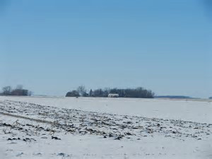
The tiny community of Emerson — population less than 700 — has seen its share of U.S. “border jumpers” over the years, but nothing like this. Until last year, residents might spot five or six strangers passing through town over the odd weekend, carrying backpacks and looking disheveled.

But since President Trump was elected last year on promises to crack down on illegal immigration and conduct “extreme vetting” of Muslims, the numbers have surged. Recently, at least 22 people sneaked across the border near Emerson in a single night, including the man with the baby, who said he was from Djibouti.

Two Royal Canadian Mounted Police vehicles pulled up to his group within minutes, lights flashing. The officers explained that they were going to arrest the migrants — six adults and three children — and drive them to a nearby border post to apply to remain in the country as refugees.

The migrants looked relieved. They are part of a small but rapidly growing population of asylum seekers who have lost hope that America will accept them and are embarking on a perilous trek north to petition for protection in Canada.

Some have already passed through up to a dozen countries, braving vast forests and raging rivers on a months-long odyssey across South and Central America before surrendering to officials at the U.S.-Mexico border. Others fly directly into major U.S. cities but, convinced they won’t receive refuge, head north from there.

Few are prepared for the harsh weather they will face on the icy prairies along the frontier between the Canadian province of Manitoba and the U.S. states of North Dakota and Minnesota.

Two men from Ghana lost most of their fingers to frostbite after getting lost in sub-freezing temperatures and are recovering in Winnipeg. Local farmers wonder whether they might find a body when the snow melts in the spring.
The two Ghanaians, Razak Iyal, 34, and Seidu Mohammed, 24, met for the first time on Christmas Eve at a bus terminal in Minneapolis.

Both men said they feared for their safety in their home country, Iyal because he had been assaulted by supporters of a rival political party, and Mohammed because he is bisexual.

But after making treacherous overland journeys to the U.S. from Brazil, they did not receive the welcome they expected. They were both detained the moment they showed up without passports at the San Ysidro border crossing between San Diego and Tijuana.

Iyal was placed in handcuffs and chains — standard procedure — for the flight to a detention facility in Arizona. “I was crying, ‘What is going on?’” he said. “Am I a criminal, or am I a terrorist or what?”

Neither could afford a lawyer to represent him in immigration court, and both lost their U.S. asylum cases.

After 22 months in custody, Iyal said, he petitioned successfully for release and went to stay with an uncle in New York while U.S. authorities tried to obtain travel documents from Ghana to deport him. Mohammed, who was freed on bond after about nine months in detention in California, joined a friend in Ohio.

Late last year, they both received word from their deportation officers that they should get ready to go back to Ghana.

In a panic, each started making inquiries about how to get to Canada. They were the only Africans at the Minneapolis station the night they met, so they caught a bus together to Grand Forks, N.D. There they found a driver willing to get them closer to the border — for $200 each.

It was past 11 p.m. and the temperature was around zero degrees Fahrenheit when the driver dropped the pair off by the side of the road and pointed in the direction of Canada.

As soon as they stepped into a farmer’s field, they sank into waist-deep snow. They had to use their hands to lift their feet out and lost their gloves. The wind picked up and blew Mohammed’s hat off. His eyelids froze shut. They both started feeling a horrible burning in their hands and feet.

Neither had ever heard of frostbite.

After walking about three hours, the men emerged onto a highway near Emerson. They could see the bright lights from the border post but were afraid to ask for help, in case they were sent back to the U.S.

Trucks lumbered by but didn’t stop. Finally, after they had waited about seven hours, a driver pulled over for them and dialed 911.

Video link: http://www.latimes.com/videogallery/

Most of those fleeing the U.S. for Canada avoid official ports of entry because of an agreement between the two countries to send back asylum seekers.

The arrangement is based on the principle, enshrined in international law, that those fleeing persecution should apply for asylum in the first safe country they reach. But once they set foot on Canadian soil, legally or not, they can petition for designation as refugees on that side of the border.

Migrant rights advocates argue that this encourages people to make dangerous illegal crossings and have called on the Liberal government of Prime Minister Justin Trudeau to rescind the agreement.

They contend that the U.S. can no longer be considered a safe place for asylum seekers to have their claims heard in light of recent orders issued by the Trump administration — including one this week that temporarily suspends refugee resettlement and bars travel from six Muslim-dominated countries.

Canada’s government so far has said it will uphold the deal with the U.S., noting that it provides “an orderly system of managing asylum claims.” But Trudeau has told Parliament that he won’t turn away refugees who enter illegally.

Bashir Khan, a Winnipeg immigration attorney, said the problems that are driving asylum seekers to flee the U.S. did not begin with Trump. “They are kind of not well-treated by the U.S. justice system,” he said.

He is representing 37 refugee claimants — including Mohammed and Iyal — who had asylum claims denied in the U.S. All were jailed upon arrival there and held for an average of seven months, he said. They had no idea how to fill out asylum forms and were not offered government-appointed lawyers.

In contrast, asylum seekers who enter Manitoba illegally are usually held for less than 24 hours, the time it takes to do security checks and file refugee claims. Local aid groups routinely help them complete the paperwork, and a government-paid attorney will represent them at the hearing — increasing the odds of a successful outcome.
Even with the recent surge, the number of asylum claims handled in the U.S. is significantly higher than in Canada, and applicants there might have to wait years for a decision because of a backlog of cases. Here, the average wait time is four months.

The number of asylum seekers crossing illegally into Canada has been growing for several years.

The biggest increase has been in Quebec province, where there are major cities on both sides of the border. The Canadian Border Services Agency said 1,280 of the refugee claims it handled in Quebec between April 2016 and early January 2017 were for people who entered illegally, three times the number in the previous fiscal year.

In Manitoba, 430 claimants entered illegally in the first nine months of the fiscal year, compared with 340 for all of 2016. The Royal Canadian Mounted Police have picked up more than 180 people in and around Emerson since then.

They include people from a number of African nations. But the biggest share, refugee advocates say, come from Somalia — one of the six countries targeted in Trump’s executive order.

Minneapolis, home to the largest Somali community in the U.S., is a six-hour drive from Manitoba. People there have seen Trump’s attempts to limit immigration and are growing increasingly fearful that they won’t be allowed to stay.

One recent border crosser said immigration enforcement agents raided the warehouse where he worked in the city. The 34-year-old Somali was still waiting for a decision on his asylum claim and hid behind machinery, afraid he too would be taken away.

He knew the trip to Canada would be dangerous, but decided he and his pregnant wife would have to risk it. Militants from the Shabab group killed his father and brother in Somalia’s war-ravaged capital, Mogadishu.

“America has changed,” he said. “That’s why I lost hope in America.”

The reception they received in Canada was very different from the U.S., he said. A pair of early morning walkers found the group they were with on the edge of Emerson and brought them home to warm up while they waited for the authorities to arrive.

The couple is now at a Salvation Army shelter in Winnipeg waiting for a hearing to determine if they can remain in Canada.

“This is our final and last hope,” said the man, who was afraid to give his name, in case it jeopardizes his refugee claim.

“It’s not only me,” he added. “There are hundreds of people coming who are fleeing from this new administration.”

The influx has been a source of tension in Emerson, a town of grain farmers, border agents, small business operators and many retirees. No one wants to leave people out in the cold. But some residents wonder why migrants are crossing illegally, and they worry about the safety of their town.

“It’s the bigger groups that are coming across that are starting to get a little more concerning,” said Greg Janzen, the chief elected official, in the Emerson-Franklin municipality. “Because as the groups get bigger, the law enforcement is going to have a hard time keeping up.”

At the Emerson Inn bar, patrons joke that Canada should build its own version of Trump’s border wall. Some people who never felt the need to lock their doors at night are now doing so.

But others aren’t so worried. Wayne Pfiel, the 46-year-old bartender, said he has talked to a number of border crossers who showed up at the hotel in the early hours. Most just wanted to know if they were in Canada and asked him to dial the authorities.

“I found one person by the front door,” he said. “I let him in and gave him a coffee…. I don’t like to see them freeze.”

When the first group of 19 Africans showed up last month, border officials didn’t have space to keep all of them at their office while they were being processed, and appealed to the town for help.

Brenda Piett, a volunteer emergency coordinator, opened up the community hall so the migrants could rest on makeshift beds. They looked hungry, she said, so she bought bread and Nutella to make sandwiches.

She doesn’t think the migrants would do anything that could jeopardize their chances to stay in Canada. “I just feel sad that they are having to make that journey,” said Piett, 57.

The Manitoba Interfaith Immigration Council, one of the main refugee resettlement agencies in the province, has been sending vans to collect the migrants after they are processed and bring them to Winnipeg. But the group’s shelter is now at capacity, so it had to enlist the help of the Salvation Army.

The Royal Canadian Mounted Police say they are mobilizing more resources and working with their U.S. counterparts to manage the flow.

In the stillness of the night, their vehicles patrol known crossing points on both sides of the border. Occasionally, an officer emerges to scan the tree line with a thermal imaging device, looking for signs of life.

When temperatures warm up, both sides are bracing for an even bigger surge.

Special correspondent Kristina Jovanovski in Toronto contributed to this report.
alexandra.zavis@latimes.com

How about a Trip to Europe Before You are Too Old!

Look! You cannot take all you have saved with you to the next dimension. I know, you want to leave your children and grandchildren an inheritance. Unless your children are seniors themselves, they are more likely to spend that inheritance than save it for a rainy day.

Consider just one or two splurges before your time to check out has come. I am not suggesting you spend your money at a casino. I know, Las Vegas makes an enticing place to spend a few days. There is more than that spending trap.

You can still walk, although slowly. You can still appreciate beautiful art and architecture.

Trafalgar offers some easy walking tours of London and Paris. Actually they take you to the door of many of the most famous places in those cities. Seven day cruises on the Mediterranean Sea can take you to some of Europe’s most famous cities.

Careful planning will not break the bank on those tours.

Bring you camera or smartphone and capture the memories.

Some of the Best Photo Spots in the world are in Europe.

y
              London Eye from nearby bridge

1107r-8-28-claude-monets-home-and-garden

Claude Monet’s Garden near Paris

Taking some of the most iconic shots is a snap when you book your one trip.
• London Eye, London
• Eiffel Tower, Paris
• Trevi Fountain, Rome
• Lagagrada Familia, Barcelona
• Santorini, Greece
• Tower of Pisa, Pisa

5 Tips for Taking the Best Vacation Photos
With a few tricks up your sleeve, the kids will be fighting over who gets to see your photos first.
1. Aim for natural light and try to avoid using flash
2. Don’t pose every shot – make candid photos of people having fun your aim
3. Capture the atmosphere by photographing food, street scenes, and the locals
4. Don’t be self-conscious – these are your memories!
5. Get a good photo editing app for your smartphone and lose the bulky camera bag

We took the Trafalgar tour in 2012 and now we are planning the cruise this coming summer.

A Hot Springs Death Reminds Park Visitors that they are in a Wilderness Area

I worked in Yellowstone National Park when I was a college student. That was a long time ago. The place is gorgeous. It’s the scenery and wildlife that cannot be found in many other places in the United States.

I remember the issues related to feeding the bears who stood in the middle of the roads begging for food. Traffic would be lined up for a mile of more as cars drove slowly past the bears. About every third or fourth car would stop and the passengers would lower their windows just an inch or two to give a begging bear some food. Employees at the park called these events “bear jams.” Every once in while a bear became angry and ripped open a window. There were lots of frightened tourists.

1960 Summer in Yellowstone Park - 180 degree hot pool at West Thumb #18 edited

Abyss Pool, Yellowstone National Park, Water temperature 192 degrees

Taken with a Kodak Pony 35MM Camera.

The board walks in the geyser areas all had signs warning visitors not to leave the walks. You could see the water in those pools and geysers was boiling hot. Steam was emitting from them. Some pools had signs by them indicating the temperature of the water.

1960 Summer in Yellowstone Park - Mammoth Hot Springs #11_edited-2

Mammoth Hot Springs.  A dirty old slide taken with a Kodak Pony 35MM Camera.

Similarly there were signs warning visitors to stay away from close encounters with wild life. So when a Black Bear approached our patio dining area in Sequoia National Park we quickly went into the cabin. The bear broke open a can of tomato sauce and ate the contents as we watched through a window.

There have been deaths as a result of exiting trails and climbing on rocks in the Merced River near Yosemite Falls.

So when someone is killed as a result of not following the posted instructions who is to blame?

Twenty three year old Colin Nathaniel Scott thought he was wiser than park rangers.

Visiting Yosemite National Park

View of Yosemite Valley at tunnel entrance Highway 41

It’s time I spent more effort on some good times rather than focusing on the bad.

When my children were small we traveled to Yosemite National Park or Sequoia National Park for nine years in succession. The first time when our first child, a baby boy, was about 1½ years old. We may have skipped a year after our baby girl was born.

It was an opportunity to get away from the city. Camping with small children is work. Still we enjoyed the change of environment.

Our favorite camp site were the Housekeeping tents in Yosemite Valley. Housekeeping Camp units consist of three concrete walls, a concrete floor, double canvas roof and a fourth curtained wall. The curtain separates the sleeping area from a covered patio area with a privacy fence that’s furnished with picnic table and bear-proof food storage containers. Each unit also includes a campfire ring with grill grate. There are public restrooms with toilet stalls and sinks. Showers are available for a fee. Electric lighting is limited to a single box near the bed racks and there is limited access to phones. You must provide your own linens and so most people bring sleeping bags. The tents are an upgrade from a conventional tent. A nearby general does have basic food supplies.

The Merced River adjoined the Housekeeping Camp area and in 6 minutes and .2 of a mile you could walk to Curry Village. Besides stores and a restaurant that is the heart of daytime activities and nighttime campfire events provided by park rangers.

There are tram tours of Yosemite Valley, bikes for rent, horseback riding, and hiking trails that even your grandmother can handle.

There is always the possibility you will see a bear or some deer. You will never forget the scenery. As you enter the park from Los Angeles through Fresno there is a grove of Redwood trees. A tram ride through that grove is worth your time. The ride to Glacier Point overlooking Yosemite Valley is equally exciting  with a view that is spectacular of the valley below and Half Dome.

Housekeeping Cabin
Housekeeping Cabin
Housekeeping Cabin in the evening


Upper Yosemite Falls

Upper Yosemite Falls

Lower Yosemite Falls in a dry year
Half Dome from Glacier Point
Open top Tram
Open top Tram


A Fun Trip with Challenges

After cancelling our trip to NYC due to repeating bad weather we decided to visit Seattle and Vancouver. Our last trip there in 1999 had its very wet periods. Drought in Northwest made this visit an easy decision.

With a departure on Jet Blue at 1:55 pm at Long Beach airport leaving the house at 10:30 am seemed a good idea. We would casually have lunch in Long Beach and drive over to the airport.

The first issue was the 101 and 405 freeways. The driving time turned out to be 1 1/2 hours. Then came the very small signs indicating a turn off of a wide Blvd. Not seeing that sign took us through the nearby oil refineries district. So instead of a casual lunch it was a mad dash to the air plane.

The long term parking is not $6.00 as I had planned. It’s $17.60 a day.

The not so fast TSA Pre check line got us to gate 7 with 10 minutes to spare. We were required to be there 15 minutes prior to take off. The plane was still disembarking passengers from the landed plane 10 minutes before our departure time. We actually started boarding 10 minutes after the scheduled depart time.

Our lunch was a muffin and bottle of water eaten after take-off. The take-off was 2:33 PM. That time the result of 5 minute delay by the Seattle control tower due to congestion at SEATAC and other unknown factors.

Happily I had made arrangements with the Hampton Inn for a car to pick us up at SEATAC and the driver called just as the plane came to a stop. No problem reaching the hotel (Hampton Inn). The hotel room is oversized but that’s OK since the nightly rate with tax exceeds $300. Dinner at the Crow a block from the hotel was a C-. It was both noisy and unappetizing.

Our one day in Seattle consisted of two round trips on the Emerald City hop on hop off bus. We did not get off once during those rides. The trips started at the Space Needle center city park. We ate lunch at the park and went through a well done fantasy museum that featured movies primarily from Star Wars and Star Trek but also included a fantasy section with costumes from Wizard of Oz and Princess Bride. The museum was well done.

Friday was our trip to Vancouver BC.
At about 8:30 am Friday morning I called Hertz to confirm the car pick up time. “We don’t have the car you reserved. We do have a Yaris.” I responded saying, “What’s the point of making a reservation over a month ago that was reconfirmed just two days ago?” The agent did not respond. I explained I need a car that will hold two regular size large suitcases. He responds that he expect a car return at 1pm.

A half hour later the Hertz agent calls to say he has a Ford Focus available now. I know this is larger than a Yaris. I ask the desk clerk to call a cab. Twenty minutes later I enter the cab for a 5 block ride. With tip that will be $10. Returning to the hotel I take a shower and shave. Wife is ready to leave.

The drive from Seattle to Vancouver went as planned until we were about 30 miles from the city. At that point we were approaching the George Massey tunnel. A sign informed us the highway would narrow to one lane through the tunnel. We sat in a 3 mile long traffic jam for 1 1/2 hours. Then the highway opened to 2 lanes. We arrived in the city in another 30 minutes.

The hotel (Holiday Inn on Broadway) is attractive and clean. Dinner was at the hotel restaurant. One prime rib 8 ounce split as we are small eaters. Breakfast at hotel is a mediocre buffet. We won’t do that again.

The hop on hop off tour of the city started from Canada Place at the harbor. Parking is $10.50 for 11 am to 6 pm seems reasonable. The two-hour ride was well worth the price. We only got off once at Prospect Point in Stanley Park. Ice cream there. The park is a beauty and a place you can spend all day visiting. We did that in 1999 on our last trip to Vancouver.

Dinner at Peaceful restaurant. It’s Chinese. It had been featured on the food channel and so was packed. It was a restaurant I had picked at random that was just a block from our hotel. When I offered my credit card they said they do not accept any credit cards. Fortunately I brought along $300 Canadian cash.

Sunday we drove to Chinatown and visited the cultural center. Lunch at Gastown across the street from the steam clock. Dinner at Cactus Club near our hotel was good.

Monday we went to Capilano Suspension Bridge. Wife did not walk across. The program there included other possible walks and climbs. Entering the facility felt like Disneyland. $35 per person but worth the price. Dinner at Earl’s on Broadway was very good and not overpriced.

Tuesday we left late from the hotel. Visited Roedde House in downtown area. It’s a house built around 1870. Lunch at Tim Hortons. Drove around center city. Back to hotel at 4:30. Wife took a nap. Dinner at Old Spaghetti Factory was good and the décor was outstanding.

Wife’s walking problems are quite bad. Future trips must take this issue into account.

Up at 7 am we are up for an early get away to SEATAC airport. My plan is to depart by 10 am for a 3 hour drive plus one hour to cross the border. We leave at 9 30 am, stop for gas and we are on the way. I miss a fork on the highway and we end up entering Vancouver airport. That cost 5 minutes. The border crossing takes only 30 minutes. We stop for lunch at the Wonderful Buffet. It’s Chinese food. As we are leaving we engage conversation with a man who says go to airport as quickly as possible because Seattle traffic can make the drive a nightmare.

He was correct. Traffic through central Seattle crawls. I see a sign saying exit 154 for airport. At exit 160 I see a sign for gasoline. Pull off find the station fill up go south to Rainier turn right take 5 south. But the traffic is slow and the signs are not clear. Finally on 5 south we see a sign saying 5 south to airport. The traffic is unbelievably slow. Cars are moving at a crawl. There are no more SEATAC signs. I get nervous and exit, find a place to park and check phone map. We have passed the airport according to my smartphone map. We head over to US 99 north rather than struggle with the slow moving freeway. 

The clock is ticking. It’s now 3:45. The plane takes off at 5:08. Driving north on 99 looking for airport entrance. It’s a small sign partially blocked by tree branches and leaves. There is no large sign. We turn in and follow signs to car return. I takes a group of 5 turns to reach the return facility. The car return is about a mile from the terminal. We park. The agent gives me a receipt. Car is quickly unloaded. A porter brings a cart for the luggage. He escorts us to a bus that takes us to the terminal.

Fortunately there is an abandoned luggage cart nearby as we exit the bus. We rush into the airport to find that we are on the lower level for arriving passengers. Wife asks someone where is the boarding area is and she is told to go to the glass elevator and take to top floor. The time is now 4:25.

We take the elevator to the upper deck. Where is the Jet Blue check in? All I see is Alaska Airlines. It must be farther down the terminal, I am rushing ahead of wife. I see the Jet Blue sign and push the cart to the ticket counter. The line is unoccupied. The lady there asks my name and finds the booking. She wants to see both of our IDs. She issues us boarding passes and incorrectly says go to the right to go through security. It’s now 4:30.

We must go thru TSA security and get to gate D5 15 minutes before departure according to Jet Blue rules. Wife is a slow walker. I urge her on. Through TSA and it’s now 4:45. We are finally on corridor D. The time is 5 P.M. We hear “last call for flight to Long Beach” on the PA. Time is 5:03.

As we approach to gate we see people waiting to board the plane. There are four or five people ahead of us. The sweat is dripping of my face and into my eyes. We have made the flight. Surprisingly another four or five other people are behind us.

We did not depart on time.

Despite the challenges we had a good time.

California Bullet Train is a Path to the Future

Driving from San Francisco to Los Angeles is a dreary six hour experience. Most people travel inland to use Interstate 5. It is a straight and boring ride. In the summer the heat in the Central Valley and the drive to the top of the Tehachapi Mountains (called the Grape Vine) causes many cars to overheat. The drive from Los Angeles does not include the steep climb but isn’t any fun either.

Today the flight from Los Angeles International Airport (LAX) to San Francisco International Airport takes about 1½ hours.  Airplane seats are narrow, poorly padded, and there is no leg room.  The time for check in and clearance through security is about 1½ hours. American Airlines recommends check in “At least 90 minutes prior to departure when checking bags.” Travel to LAX is about 1½ hours. Thus a 1½ hour flight requires 4½ hours. The flight costs $124.00 round trip. Currently the travel time by rail is about 12 3/4 hours.   Obviously train travel is not acceptable to most people as the train does not actually go into San Francisco. The last leg of the trip is a bus ride from Emeryville across San Francisco Bay.

The Bullet Train project plans that by 2029 the system will run from San Francisco to the Los Angeles basin in under three hours at speeds capable of over 200 miles per hour. If the train cost is competitive with air travel we will see a new era for travel. We will be able to reach the center of each city without a special effort. The airlines will cut their fares to continue drawing patrons.

Despite the naysayers, I believe Governor Jerry Brown is correct in perusing this project.

CA Bullet Train Map

West Coast’s Tallest Tower Finally Getting Sky-High View Deck

US bank bldg top floors

photo from LA Curbed

Arrow points to planned new observation deck

 This will be great for business.  Tourists will be flocking downtown.

The owners of the 72-story US Bank Tower, the tallest building on the West Coast (for now), will open up a public viewing deck like a real Empire-State-building-style tourist trap. The building is 310.3 m (1,018 ft). Top floor, 294.92 m (967.6 ft).  Maybe next they’ll light the Hollywood Sign! The 1989 building, formerly known as the Library Tower, will stay an office building, but get a new observation area on the sixty-ninth and seventieth floors, which will be connected by a new stairway; existing terraces on the sixty-ninth will be opened up as well, reports the LA Times. Meanwhile, the seventy-first floor, which has 18-foot ceilings and 360-degree views of Los Angeles, will get a new restaurant.

Plus new entry for tourists and a very high price. >>

US Bank visitors will enter through a new second-floor portal with upgraded elevators and newish owners Overseas Union Enterprise Ltd. will also give the US Bank sign a “modernization” and add a curb cut at the Fifth Street entrance for passenger loading and unloading. Local mega-firm Gensler will design all of the changes.

Tourist traps do not come cheap: OUE will charge $25 a head, but thinks it can pull in half a million visitors a year. Broker/blogger Brigham Yen found that pricing is in the range for similar attractions: Chicago’s Willis Tower costs $19, the Empire State Building is $29 to the eighty-sixth floor. CN Tower in Toronto Canada costs $28.80 – LookOut Level at 346 m (1,136 ft.).

Not too far away from the US Bank building, however, the Wilshire Grand hotel/office building is under construction and set to be the new tallest tower in the West when it’s finished in 2017. It will have an observation deck, infinity pool, and restaurant on its roof, which according to Yen will still be lower than the US Bank Tower’s new deck.


source http://la.curbed.comUS Bank Bldg from 5th and Fig

my photo taken with Panasonic FZ150

Los Angeles Union Station Reaches 75

LA Union StationIt was August 1948 when I arrived in Los Angeles. My first view of this city was the parking lot lined with the tall Mexican Fan Palm trees.   Thousands celebrated the 75th anniversary of the iconic Union Station in L.A yesterday. I was there once again.

It’s not the most beautiful building but for many it evokes memories. If nothing else the anniversary celebration provoked a cleaning and polishing of the facility. Recent add-ons to the station have made it a far more attractive site.

Public transportation has received a very big boost in Los Angeles over the past 20 years. This facility has become a significant transit center for that development. Freeways have not provided the transit solution that many believed would be the future for this metropolitan area.

More photos on Los Angeles Photo Gallery link.